
Push grows to disclose national sinkhole risk maps
Push grows to disclose national sinkhole risk maps
Posted June. 26, 2025 07:58,
Updated June. 26, 2025 07:58
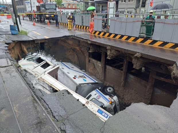
A nationwide project to map South Korea’s underground in order to prevent deadly sinkhole accidents is facing sharp criticism for omitting crucial data and being largely inaccessible to the public. Experts and civic groups argue the maps exclude essential information such as previous sinkhole locations, underground water flow, and buried infrastructure, all of which are vital for accurate risk assessment.
The Ministry of Land, Infrastructure and Transport began the “integrated underground map” project in 2014 following a major sinkhole in Seoul’s Songpa District. The ministry invested 78.5 billion won to identify collapse-prone areas, but public usage has remained extremely low. According to a recent Dong-A Ilbo investigation, only 403 people accessed the system between January and May 2025, averaging about two users per day. The platform requires prior approval and is limited to developers and authorized personnel. Ordinary citizens cannot access the system.
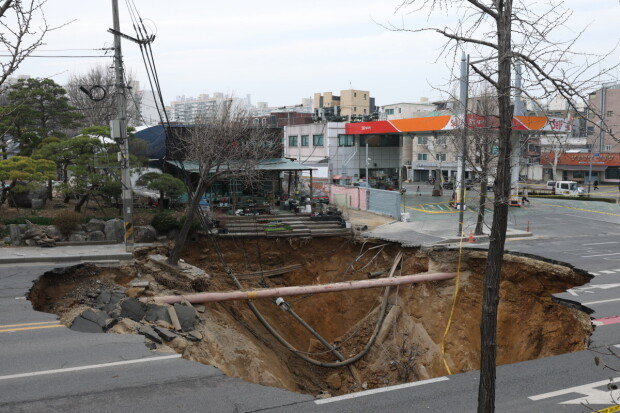
Busan, the city with the highest number of large sinkholes—seven out of 35 since 2018—has created its own “ground sink danger map,” but has chosen not to release it to the public. Seoul has developed a similar “sinkhole safety map” but also enforces a nondisclosure policy.
In response, several lawmakers are pushing to amend the Special Act on Underground Safety Management to require local governments to both create and publicly disclose sinkhole risk maps. Democratic Party lawmakers Ahn Tae-joon and Yoon Jong-gun have introduced separate bills that would mandate government action in risk zones. The proposed penalties for noncompliance include up to two years in prison or fines of up to 20 million won. Rep. Hwang Myung-seon has also introduced a revision to the Framework Act on National Spatial Data Infrastructure, which calls for the release of all spatial data relevant to public safety.
The lack of transparency has sparked backlash. “The public has a right to know what’s beneath their feet,” said Lee Seong-han, director general of the Healthy Society Welfare Association in Busan. “A detailed, accessible map of underground safety risks is essential to building public trust and protecting lives.”
Experts in civil engineering agree that reform is needed. Choi Chang-ho, a senior researcher at the Korea Institute of Civil Engineering and Building Technology, has called for a risk map that classifies urban areas into safe and vulnerable zones based on data. He emphasized that such information must be made widely available to the public.


![“1000만원 줄 테니 나가달라”…집주인 제안, 받아도 될까 [집과법]](https://dimg.donga.com/c/138/175/90/1/wps/NEWS/IMAGE/2026/06/19/134130634.3.jpg)
![‘월급 50만원, 아파트는 4억’ 베트남…청년들 “그냥 평생 월세 살란다”[딥다이브]](https://dimg.donga.com/c/138/175/90/1/wps/NEWS/IMAGE/2026/06/19/134141662.1.png)
