
Super typhoon Hinnamnor expected to land Busan on Tuesday
Super typhoon Hinnamnor expected to land Busan on Tuesday
Posted September. 03, 2022 07:42,
Updated September. 03, 2022 07:42
Super typhoon Hinnamnor, the 11th cyclone for the year, is expected to land on Korea’s Busan and the southern coastal areas in South Gyeongsang Province on Tuesday, changing its course from what has originally been anticipated. The typhoon's course may move to west, raising possibilities of penetrating through the inland. Under the situation, emergency preparations against the super strong typhoon are now more urgent than ever as the storm may have a significant impact on Korea's metropolitan areas including Seoul as well as its southern provinces.
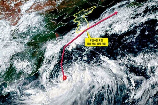
In its emergency briefing held on Friday, the Korea Meteorological Administration (KMA) announced that the typhoon Hinnamnor is expected to land on the coastal areas of South Gyeongsang Province. According to the agency, the typhoon is most likely to arrive in the coastal areas of Busan in the early morning of Tuesday. The KMA initially forecasted until the day before the briefing that the typhoon would pass by 50 kilometers off the coast of Busan City into the Straits of Korea.
But the anticipated path has been changed in just one day, from passing by to landing. The KMA explained that the path changed because the high atmospheric pressure in the North Pacific located in the eastern part of the typhoon has expanded, possibly pushing the cyclone further to the west.
By the time Hinnamnor lands on the Korean Peninsula between Monday evening and Tuesday morning, its central pressure is expected to reach between 940 and 950hPa. Typhoon Sarah in 1995 and Typhoon Maemi in 2003, both of which devastated the country, recorded central pressures of 951.5hPa and 954hPa, respectively. The lower the central pressure is, the stronger the typhoon becomes as it sucks in the air around. The wind speed of Hinnamnor is expected to surpass 50 meters per second (180 kilometers per hour), which means the typhoon would be strong enough to send people flying and destroy buildings.
The path of Hinnamnor might move further to the west, depending on the wind speed of the typhoon center and the surrounding atmospheric pressure systems. The KMA's analysis system (data model) predicted that the typhoon may land on the coastal areas of South Jeolla Province, brushing the western part of Jeju Island. In that case, the typhoon will be sweeping larger areas of the country. And some of the South Gyeongsang areas and Jeju Island may even fall into the ‘dangerous semicircle,’ the side of a tropical cyclone to the right of the direction of movement whose winds are stronger because the cyclone's translation speed and rotational wind field are additive.
Mee-Jee Lee image@donga.com

![[오늘의 운세/7월 6일]](https://dimg.donga.com/c/138/175/90/1/wps/NEWS/IMAGE/2026/07/06/134241070.1.jpg)


