

South Korea launches first homegrown farm satellite
South Korea launches first homegrown farm satellite
Posted July. 06, 2026 08:37,
Updated July. 06, 2026 08:37
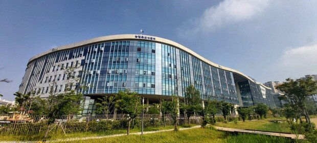
South Korea is preparing to launch its first domestically developed satellite dedicated to agriculture and forestry, giving the country its own space-based platform for monitoring farmland, forecasting crop production and managing forest resources. The satellite will capture images of the entire Korean Peninsula every three days.
The Ministry of Agriculture, Food and Rural Affairs said the Agriculture and Forestry Satellite, also known as Next-Generation Medium Satellite 4, is scheduled to launch aboard a SpaceX Falcon 9 rocket from Vandenberg Space Force Base in California at 4:10 p.m. Monday local time, or 12:10 a.m. Tuesday in South Korea. About two hours and 22 minutes after liftoff, the satellite is expected to separate from the rocket before attempting its first communication with the Svalbard ground station in Norway roughly 31 minutes later.
The Agriculture and Forestry Satellite is the first satellite developed independently by South Korea specifically for agricultural and forestry operations. It was jointly developed by the Korea AeroSpace Administration, the Rural Development Administration and the Korea Forest Service to reduce the country's dependence on foreign satellite data. Equipped with 5-meter spatial resolution, a 120-kilometer imaging swath and a three-day revisit cycle, it will provide regular coverage of the entire Korean Peninsula. It also carries five spectral bands designed to distinguish crop growth and forest conditions, making it well suited for monitoring South Korea's agricultural and forestry resources.
The agriculture ministry plans to use the satellite to inspect farmland use and verify compliance with the country's public direct payment program. Artificial intelligence will analyze satellite imagery to identify idle farmland, agricultural facilities, forested areas and parcels requiring further review, allowing inspectors to focus on locations that need on-site verification. The government also plans to continuously cross-check farm registration data, including crops under cultivation, to prevent fraudulent subsidy payments.
The satellite will also strengthen the government's management of agricultural supplies. Officials plan to monitor planting areas for price-sensitive crops such as vegetables, along with the growth of staple crops including rice and soybeans, to improve crop yield forecasts and respond more quickly to sudden price swings. The system is also expected to spot early signs of crop diseases and pest damage. In addition, the government plans to use the satellite for disaster response, monitoring changes in rural land use and gradually expanding access to satellite data for private companies and the public.
세종=김수연 기자 syeon@donga.com


![[단독]삼전닉스 임원, 상반기 자사주 173억 매도…1년전의 14배](https://dimg.donga.com/c/138/175/90/1/wps/NEWS/IMAGE/2026/07/07/134248269.1.jpg)



 About Dong-A Ilbo