IPIN LABS: Overcoming the Limitations of GPS to Monitor Industrial Assets
IPIN LABS: Overcoming the Limitations of GPS to Monitor Industrial Assets
Posted December. 19, 2024 10:00,
Updated December. 19, 2024 10:00
IPIN LABS is a company that develops technology that can be used to track the location of people or objects in indoor spaces where GPS cannot be used. By integrating inertial measurement sensor data with signals from Wi-Fi, BLE (Bluetooth Low Energy), and 5G infrastructure installed indoors, the company provides SLAM (Simultaneous Localization And Mapping) solutions. I interviewed Seon-hyeok Kang, COO of IPIN LABS, to explore the technology's principles, applications, and advantages.
 Seon-hyeok Kang, COO of IPIN LABS / Source: IT Dong-A
Developing SLAM Solutions to Overcome the Limitations of GPS: ‘IPIN LABS’
The Global Positioning System (GPS) determines a user’s location using signals sent from satellites. While it is highly accurate outdoors, GPS generally performs poorly indoors, as satellite signals are blocked or refracted by building structures. Indoor positioning solutions to address this issue have been developed, but often require the installation of costly equipment, including electrical and communications network work.
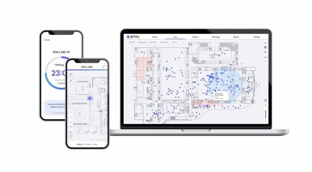
“Previous attempts to overcome the limitations of GPS indoors relied heavily on anchor-based systems using Ultra-Wideband (UWB), which require communication network construction. This incurs high installation costs and takes 4 to 6 weeks to complete. As well, any changes to the indoor space or equipment malfunctions result in extended maintenance periods,” explained Seon-hyeok Kang. “In contrast, our SLAM solution integrates signal data from existing indoor infrastructure, such as Wi-Fi, Bluetooth, and 5G, with data from inertial measurement sensors attached to monitoring targets. It tracks positions while simultaneously mapping the environment.”
 Overview of the SLAM solution developed by IPIN LABS / Source: IPIN LABS
He added, “Since we utilize existing infrastructure like Wi-Fi, there is no need for additional communication network construction, which significantly reduces the costs. Our deep learning algorithms allow the system to easily adapt to changes in the indoor environment, and deployment can be completed within 24 hours.”
 Demonstration of IPIN LABS’ SLAM solution in operation / Source: IPIN LABS
IPIN LABS’ SLAM solution is expected to help reduce costs at Incheon International Airport.
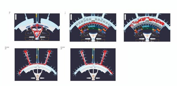
Seon-hyeok Kang stated, “One of the key organizations where we are conducting a Proof of Concept (PoC) is Incheon International Airport Corporation. The airport makes various items available for passenger convenience, such as carts, strollers, and wheelchairs. These are often misplaced, resulting in recurring expenses for replacements. With our solution, we can monitor these items in real time, reducing unnecessary costs. Currently, we are collecting data throughout Terminal 1, as we analyze and test our solution.”
 Implementation of the SLAM solution at Incheon International Airport / Source: IPIN LABS
He continued, “We are also conducting PoC work with Seoul National University Hospital to monitor the location of medical equipment, and with semiconductor companies for asset control pilot projects to track the exact location of high-value manufacturing equipment. In addition, we are in discussions with organizations such as France’s SNCF, Taiwan’s Wistron, and Japan’s NEC regarding solution deployment. Our system also integrates a geofencing feature, which allows users to designate restricted zones for safety and security. If someone enters one of these zones, the system triggers immediate alerts and messages.”
Customizing Solutions for Industry-Specific Needs: Securing References as a Challenge
Although IPIN LABS successfully developed its SLAM solution to overcome the limitations of GPS indoors, there are still challenges to overcome before rapid growth can be achieved.
“In the early stages, we only had the core algorithm, and it took us about a year to build the complete solution. Now that we are conducting PoCs with various enterprises, we are facing different demands due to industry-specific requirements. For example, semiconductor companies need location tracking for static equipment only about three times a day. In contrast, at Incheon International Airport, assets like carts and strollers move constantly, and require outdoor tracking as well,” explained Seon-hyeok Kang.
“To meet these diverse requirements, we are enhancing our solution while working with large enterprises to secure references. By verifying our technology through PoCs and building a robust portfolio, we expect to accelerate our business expansion,” he added.
The Seoul Business Agency (SBA) is actively supporting IPIN LABS in overcoming challenges and expanding globally.
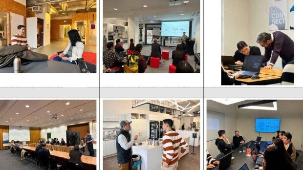
“SBA provides multiple forms of support to help us enter international markets. For example, through the SBA’s German program, we received mentoring for market entry and acceleration support to expand our local network. Thanks to this program, we held meetings with major German companies like Lufthansa, Maxion Wheels, and Deutsche Bahn’s open innovation subsidiary, DB mindbox,” said Seon-hyeok Kang.
 IPIN LABS participate in SBA's German program and meet local companies / Source: IPIN LABS
He added, “Through our direct experience in Germany, we realized that communication within German companies, especially across departments, takes a considerable amount of time. We learned the importance of maintaining longer collaboration timelines, such as during PoCs. Currently, we are engaging with open innovation departments in German firms on a continued basis to share customer success cases. SBA provides ongoing mentoring and support during this process. In addition to overseas efforts, we are working to complete the asset control project with domestic semiconductor companies. Our goal is to enhance our solution so that we can enable anyone to easily monitor assets indoors, developing technology with a value that is comparable to GPS.”
by Dong-jin Kim (kdj@itdonga.com)

Developing SLAM Solutions to Overcome the Limitations of GPS: ‘IPIN LABS’
The Global Positioning System (GPS) determines a user’s location using signals sent from satellites. While it is highly accurate outdoors, GPS generally performs poorly indoors, as satellite signals are blocked or refracted by building structures. Indoor positioning solutions to address this issue have been developed, but often require the installation of costly equipment, including electrical and communications network work.
“Previous attempts to overcome the limitations of GPS indoors relied heavily on anchor-based systems using Ultra-Wideband (UWB), which require communication network construction. This incurs high installation costs and takes 4 to 6 weeks to complete. As well, any changes to the indoor space or equipment malfunctions result in extended maintenance periods,” explained Seon-hyeok Kang. “In contrast, our SLAM solution integrates signal data from existing indoor infrastructure, such as Wi-Fi, Bluetooth, and 5G, with data from inertial measurement sensors attached to monitoring targets. It tracks positions while simultaneously mapping the environment.”

He added, “Since we utilize existing infrastructure like Wi-Fi, there is no need for additional communication network construction, which significantly reduces the costs. Our deep learning algorithms allow the system to easily adapt to changes in the indoor environment, and deployment can be completed within 24 hours.”

IPIN LABS’ SLAM solution is expected to help reduce costs at Incheon International Airport.
Seon-hyeok Kang stated, “One of the key organizations where we are conducting a Proof of Concept (PoC) is Incheon International Airport Corporation. The airport makes various items available for passenger convenience, such as carts, strollers, and wheelchairs. These are often misplaced, resulting in recurring expenses for replacements. With our solution, we can monitor these items in real time, reducing unnecessary costs. Currently, we are collecting data throughout Terminal 1, as we analyze and test our solution.”

He continued, “We are also conducting PoC work with Seoul National University Hospital to monitor the location of medical equipment, and with semiconductor companies for asset control pilot projects to track the exact location of high-value manufacturing equipment. In addition, we are in discussions with organizations such as France’s SNCF, Taiwan’s Wistron, and Japan’s NEC regarding solution deployment. Our system also integrates a geofencing feature, which allows users to designate restricted zones for safety and security. If someone enters one of these zones, the system triggers immediate alerts and messages.”
Customizing Solutions for Industry-Specific Needs: Securing References as a Challenge
Although IPIN LABS successfully developed its SLAM solution to overcome the limitations of GPS indoors, there are still challenges to overcome before rapid growth can be achieved.
“In the early stages, we only had the core algorithm, and it took us about a year to build the complete solution. Now that we are conducting PoCs with various enterprises, we are facing different demands due to industry-specific requirements. For example, semiconductor companies need location tracking for static equipment only about three times a day. In contrast, at Incheon International Airport, assets like carts and strollers move constantly, and require outdoor tracking as well,” explained Seon-hyeok Kang.
“To meet these diverse requirements, we are enhancing our solution while working with large enterprises to secure references. By verifying our technology through PoCs and building a robust portfolio, we expect to accelerate our business expansion,” he added.
The Seoul Business Agency (SBA) is actively supporting IPIN LABS in overcoming challenges and expanding globally.
“SBA provides multiple forms of support to help us enter international markets. For example, through the SBA’s German program, we received mentoring for market entry and acceleration support to expand our local network. Thanks to this program, we held meetings with major German companies like Lufthansa, Maxion Wheels, and Deutsche Bahn’s open innovation subsidiary, DB mindbox,” said Seon-hyeok Kang.

He added, “Through our direct experience in Germany, we realized that communication within German companies, especially across departments, takes a considerable amount of time. We learned the importance of maintaining longer collaboration timelines, such as during PoCs. Currently, we are engaging with open innovation departments in German firms on a continued basis to share customer success cases. SBA provides ongoing mentoring and support during this process. In addition to overseas efforts, we are working to complete the asset control project with domestic semiconductor companies. Our goal is to enhance our solution so that we can enable anyone to easily monitor assets indoors, developing technology with a value that is comparable to GPS.”
by Dong-jin Kim (kdj@itdonga.com)
Headline News
- Acting president fills key court vacancies, opposition cries foul
- Graham Allison raises alarm over 'Thucydides Trap' as U.S.-China tensions rise"
- Samsung posts 6.6 trillion won operating profit in Q1
- Chinese teens caught filming Air Force jets without authorization
- S. Korea’s early presidential election set for June 3


