
Earthquake hits Korea's southwestern region
Earthquake hits Korea's southwestern region
Posted June. 13, 2024 09:39,
Updated June. 13, 2024 09:40
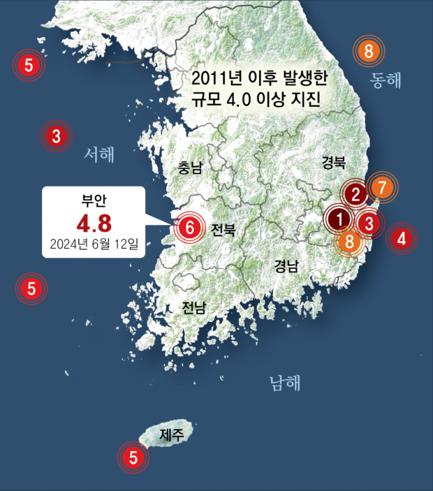
An earthquake with a magnitude of 4.8 struck 4 kilometers south-southwest of Buan County, North Jeolla Province, around 8:26 a.m. on Tuesday. This was the largest of the 32 earthquakes that have occurred on the Korean Peninsula and surrounding waters this year and the strongest ever for an earthquake in the southwestern region of Korea. Several damages occurred in Buan, the epicenter, including cracked building walls and ceiling collapses. The impact was felt across the country, with more than 300 reports of ‘feeling shaken’ received from Seoul, Busan, and Gangwon. Following the initial quake, at least 15 large and small aftershocks were recorded. Fortunately, there were no casualties, and the Hanbit Nuclear Power Plant in Yeonggwang County, South Jeolla Province, remained undamaged and operational.
This earthquake is unusual in that it occurred on the West Sea, where earthquakes are relatively rare and considered an earthquake-safe zone. Since 2011, eight earthquakes of magnitude 4.0 or higher have occurred in Korea, but the recent one was the first to occur in the western inland. There have been larger earthquakes on the west coast, but there was no damage because they occurred in waters far from the land. Moreover, this earthquake is the largest inland earthquake since the 2017 Pohang Earthquake in North Gyeongsang Province. It can be said that any region in Korea is prone to earthquakes of scale that are impossible to ignore.
Earthquakes usually occur when faults move due to tectonic shifts, but it has not been confirmed which fault the earthquake occurred on. This lack of fault information in the area is a significant challenge in earthquake prediction and preparedness. The government started research on faults in Korea after the 2016 Gyeongju earthquake in North Gyeongsang Province and the 2017 Pohang earthquake in 2017, but there has been no study at all in the Jeolla area as it was deprioritized by the metropolitan and east coast areas. Due to the rare history of strong earthquakes and shallow waters on the West Sea, the risk of the tsunami was considered relatively low. It is questionable how the government plans to predict and prepare for earthquakes when we do not know where and how many faults there are.
Experts say that there have been some earthquakes in the West Sea area; we simply do not recall them as the cycle has been relatively long. Once an earthquake occurs, surrounding faults may be stimulated, causing a larger earthquake. There have been frequent strong earthquakes centered around the Gyeongju area over the past ten years, believed to be impacted by the 2011 Great East Japan Earthquake activating faults on the Korean Peninsula. The need for creating fault maps as soon as possible is underscored by these events. The importance of earthquake preparedness was excellently demonstrated by Taiwan, which escaped any major damage from a magnitude 7.2 earthquake in April this year.


