A Panorama of Rocks

The change in season can definitely been seen in the mountains. I havent noticed the arrival of the new season because Ive been surrounded by high-rise buildings. But full-blown forsythias and azaleas welcomed climbers at the entrance of Mt. Yongbong.
I went to Mt. Yongbong, which encompasses Hongbuk-myeon of Hongseong-gun, and Deoksan-myeon and Sapgyo-eup of Yesan-gun, in South Chungcheong province last weekend.
I began walking from a parking lot nearby Yongbong Elementary School. Typical country houses lining the entry path up the mountain reminded me of my childhood.
Ten minutes of a gentle pace on the asphalt pavement led me to a statute of Maitreya of Yongdo Temple. At the temple, a person new to the mountain may think, its very easy to climb since the mountain is not high.
However, it is quite steep from the temple to the ridge linking to the peak. Even though I was wearing a thin jacket, I sweat a lot and changed the wet jacket for a short-sleeved shirt. Spring was nearly gone and summer was upon us.
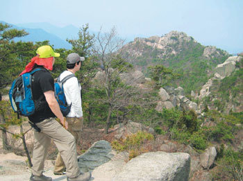
It took 30 minutes from the statute to the ridge. On the ridge, where the mountain spreads out before the climbers, I saw a different aspect of the mountain--the mountain was rocky. Then, I realized that the name of the mountain was truly meaningful. Yongbong comes from the shape of the mountain, which looks like the body of a dragon and the head of a phoenix. (Yong means dragon and bong refers to phoenix.)
The rocky peaks looked marvelous. Thats why the mountain is also known as a smaller version of Mt. Geumgang, a beautiful mountain in North Korea.
It takes just a few minutes from the ridge to the mountain top. The height and name of the mountain are engraved on a big rock at the summit. There, I could see Mt. Deoksung (495m) in Yesan, Mt. Gaya (678m) in Seosan, and Yedang Plain.
There was a pavilion at the northeast part of the mountain. Ive heard that it was where General Choi Yeong of the Goryeo Dynasty mastered archery. I could have seen more if the weather was clear. But, the air was full of mist.
While coming down from the summit, I passed by Nojeok Peak and Akgui Peak. Going both up and down the mountain path was fun. Even wooden stairs and balustrade have been installed along steep portions of the path.
After quenching my thirst at the temple and walking down a bit more, I arrived back at the parking lot. Excluding the 40 minutes for lunch, which was taken just below the mountains summit, the entire hike took just 2 hours and 30 minutes of gentle walking.
Climbers who want to enjoy more of the mountain can walk down along the ridge, instead of coming down to the temple near Akgui Peak. That will take around four hours.
kimsk@donga.com


