
Its Earthy Breast Dug up to the Ridges
Its Earthy Breast Dug up to the Ridges
Posted February. 17, 2005 22:51,
I feel sorry for Mt. Jiri.
In Pyeongsa-ri, the skirts of Mt. Jiri overlook the fields of Akyang by the banks of Seomjin River. Park Kyung-ree, author of the famous Land (Korean title: Toji), is said to have uttered the above lament when she saw the mansion built on the same mountainside, to re-create Champan Chois estate from the novel (a champan is a high-ranking government official from the Joseon period). Considering the fact that a consistent theme in Land is life, one can well imagine what Park must have meant when she remarked on a house built by digging up the mountainside.
Standing upon the Ridge at 1370m, the Mountain Range Aligns Itself
1070m above sea level, on Mt. Jiris Seongsam-jae. This treacherous mountain road (local route 861) connecting Gurye and Namwon is a ridgeline pass over the Baekdu Daegan mountain range.
Since the road takes you right over the Daegans ridge, its no wonder that the vista commanded from its highest point is celebrated by word of mouth. From this vantage point, the main range of Mt. Jiri stands out clearly all the way from the summit of Nogodan (老姑壇1507m) above to Goribong and Manbokdae to the side. Far off, the broad expanse of Sandong (Gurye-gun) also offers a breathtaking prospect.
But for true mountain lovers, the existence of this Mt. Jiri Sightseeing Road is somewhat questionable. Whats more, a recent study conducted by Seoul National University professor Park Jong-hwa and his team found that the road has cut off the path of the mountains wildlife, thus leading inevitably to a breakdown in the food chain and a general disturbance of the ecosystem.
But since theres meaning in finding a way to coexist with nature as one follows the sightseeing road from Seongsam-jae over the ridgeline up to Nogodan, I purposely included the Seaongsam-jae~Nogodan course in my long trek along the Baekdu Daegan.
Traveling north along route 19 from Ha-dong, you pass the wide fields of Akyang, the famous Hwagye Marketplace, and Ssanggye Temple to arrive at Gurye. Switching onto the Mt. Jiri Sightseeing Road No. 861 from here, you pass Cheoneun Temple and enter the winding mountain trail. The steep and treacherous ascent requires precise driving skills bordering on acrobatics. In the winter, the road is often closed off altogether due to ice, so its easy to find yourself frustrated if you dont inquire in advance.
So why do people flock continually to this place? Its simple. Because this path up to Nogodan affords the opportunity to walk the ridgeline of the Baekdu Daegan without exerting yourself beyond the level of hiking, as well as to enjoy Mt. Jiris grand panorama, with its ocean of clouds, snowy landscape, and spectacular summits.
There are two ways to climb Nogodan: the paved road extending to the shelter at Nogodan, or the ridgeline trail that takes you up via Jongseok-dae (1356m). The snow-covered cement road offers a gentle ascent, ideal for walking while chatting with a companion. After climbing for about an hour, the road merges with the track up to Hwaeom Temple, at which point you can meet seasoned mountain climbers who have braved over three hours of hard going. Once you arrive at the shelter, Nogodan Hill (1370m) is a mere 20 minutes away.
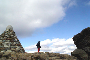
A Stone Pagoda Stands Alone at the Ceremonial Site Where People Used to Pray for the Countrys Welfare
On the hilltop, you cannot help uttering words of awe and admiration. Directly in front, Banyabong embraces the tired traveler, while from further off the peaks of Jubong, Cheonwangbong, and Seseokpyeongjeon send their silent greeting. At a glance, you see the entire main ridgeline of the Baekdu Daegan, stretching over 32.3km all the way to Cheonwangbong. From the hill, the summit of Nogodan is in plain sight. But traffic to the summit has been prohibited, to prevent further damage to the ecosystem.
On the hill, theres a stone pagoda (a ceremonial altar) identical to the one standing on the summit. As a result, some mistake the hill for the summit itself.
Nogodan was the site of ritual ceremonies during the Goryeo and Joseon periods, where people gathered to pray for a good harvest and the welfare of the nation. The grassy area is a rare example of a sub-alpine zone within Korea. Its a highland flower garden where the day lily, the lychnis, and the cranes bill burst into bloom in late July and early August. The Nogo Ocean of Clouds, numbered among the 10 spectacles of Mt. Jiri, can be seen in midsummer and fall.
Traveling Information:
Directions = Gyeongbu Expressway∼Daejeon∼Daejeon Tongyeong Expressway △ Via Hamyang = Hamyang Junction∼88 Olympic Expressway∼Mt. Jiri Nadeulmok∼Route 60∼Macheon~Sannae∼Route 861∼Banseon∼Seongsam-jae Service Area △ Via Gurye = Jangsu Nadeulmok∼Route 19∼Namwon∼Gwangeui (Gurye-gun)∼Route 861∼Cheoneun Temple∼Siam-jae∼Seongsam-jae Service Area
▽ Mountain Trail △ Seongsam-jae Service Area∼Nogodan Hill = 2.3km (one hour∼one hour 30 minutes) △ Nogodan Hill∼Summit = Roundtrip 1.5km (one hour)
▽ Inquiries △ Reservations for Nogodan (Summit) Trips = Due to severe damage to the ecosystem, open only four times a day (100 visitors per trip) during May~October by reservation. Register a month to two days prior to trip on the homepage. △ National Parks Authority (www.npa.or.kr) Mt. Jiri South Office = 061-783-9100 △ Nogodan Shelter = 061-783-1507 △ Gurye Taxis = 061-783-5000
▽ To Nogodan on Foot = The Save Jirisan Association, which has been demanding the efficient management of the Mt. Jiri Sightseeing Road, holds this walkathon in October each year, as a way of returning the road to nature.
Seung-Ha Cho summer@donga.com


