A 1,176-Meter Summit Where Three Provinces Meet
A 1,176-Meter Summit Where Three Provinces Meet
Posted March. 17, 2005 22:49,
The ridgelines of the high and steep peak Baekdu Daegan, which lies Northeast from Namdeokyu, passes Dongyeop-ryeong (1,320m) near Hyangjeok-bong (1,614m) and the summit of Deokyu mountain, and passes another peak, Baekam-bong (1,480m), before heading downwards. It then extends through Gui-bong (1,400m) and Dae-bong (1,190m), arrives at Baejae (namely, Shinpoong-ryeong, 930m), and finally climbs its way over the Daegan.
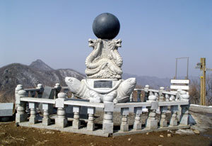
The ridgeline that heads upwards from Baejae climbs up to Sujeong-bong (1,030m) on Sambong Mountain (1,245m), takes a steep descent to Sosa hill (690m) where youll find Samdo-bong (1176m), so named because three provinces of Gyeongbuk, Chungbuk, and Jeonbuk meet there. Samdo-bong is an elegant peak where the ridgeline hits the base of the hill and wins past Daedeok Mountain (1290m) to rise up vigorously to the sky.
Harmony Festival of the Residents of Jeolla-Chungcheong-Gyeongsang Provinces
We set off for Sosa hill (690m) to follow the ridgeline that stretches past Daedeok Mountain on to Samdo-bong. This hill stands in the path of the 1089 local highway that links Muju (Mupung-myeon) of Jeonbuk with Geochang (Geoje-myeon) of Gyeongnam. But the map showed a curious detail. The boundary line of the provinces lay outside the ridgeline of the Daegan and slanted towards Buksa-myeon (near Muju). It went against the conventional rule of setting the ridgeline as the boundary line for provinces or districts.
Villages in the regionincluding Sosa-dong, Jigyeongnae, and Buheung-dong, which have coexisted in intimate harmony under the roof of Sosa hillare split down the middle into Jeolla-do and Gyeongsang-do, even though the villagers have been living intimately throughout, sharing water from the stream set as the boundary line between the provinces and calling on each other on happy or sad occasions. The head of the village, Park Bong-rok (71) of Bongye-ri, which lies along the boundary, tells us that There are villagers with property in Sosa-dong (Geochang) who farm there but pay their taxes to Geochang province.
The situation becomes more frustrating when you look at the bus stop in Buheung-dong (Mupung-myeon, Muju-gun) where the boundary line lies. The city buses of Geochang and Muju all turn back at the boundary line. The monument erected for the harmony of the three provinces in Samdo-bong isnt far away and every year a festival celebrating the harmony of the three provinces is held but administration cuts off Geochang and Muju in this abrupt manner.
The Spring Sun and Melting Snow The Milky-White Mountain Scenery
On the way up the ridgeline of the Daegan, after leaving Sosa village. The road leads up to Samdo-bong, past Buhang-ryeong where the hill track has disappeared after the tunnel construction in 2000. The climb that started off on the right foot in Muju and on the left in Geochang (Gyeongnam) steps into Gimcheon (Gyeongbuk) on the right foot once it nears Daedeok mountain. However, up on Samdo-bong, you have the special experience of stepping on the earth of Jeonbuk, Gyeongbuk, and Chungbuk, all at once.
The three provinces of Samdo-bong are Chungbuk (Yeongdong district), Gyeongbuk (Muju-gun), and Jeonbuk (Muju district). There are three Samdo-bongs along the Baekdu Daegan of South Korea. The three are Nalnari-bong (1490m) of Jiree Mountain, Samdo-bong (1250m) of Daedeok Mountain, and the Samdo-bong that you find here, but the stories behind these other summits differ from the one we have seen today.
The other two are on the boundary of between the two provinces of Gyeongsang and JeollaGyeongnam and Jeonnam-Jeonbuk, and Jeonbuk and Gyeongnam-Gyeongbuk, respectivelybut at this Samdo-bong the boundary of three provinces, Gyeongsang, Jeolla and Chungcheong, converge. Moreover it is said to have been the boundary between Mahan, Jinhan, and Byeonhan in the Samhan era, from which we might say that this one is the best of the Samdo-bongs.
The summit of Samdo-bong, where the snow covering all the mountains is melting under the warm spring sunlight. The mountain scenery was milky-white, because of the evaporated moisture. Through the mist, we found a high mountain rising in the northeast whilst following the ridgeline of the Daegan. It was Mount Hwangak (1111m). Follow that mountain range and out leaps Chupungryeong hill, where Gyeongbu Expressway passes.
Tourism information-
How to get there-
Samdo-bong: starts at Mulhan valley (Sangchon-myeon) in Yeongdong, Chungbuk province. Gyeongbu Expressway-Hwangkan Interchange (IC)-National Highway #49-Samdodae three-way junction-Mulhan valley (24km from the Hwangkan Interchange).
Popular restaurants-
Jiryae-myeon in Kimcheon-si has long been famous as a receiving and distributing center of local black pigs. There are as many as 12 black pig restaurants in Gyo-ri in which a myeon office is located. Black pig is famous for its tasty meat and light taste.
An original Jang Young-sun black pig restaurant on the three-way junction in Jirye has been there over the last 50 years and the owner, Jang, has been running the restaurant for the past 18 years.
The price for one portion of pork roast with salt and seasoned bulgogi is 6,000 won. Beanpaste pot stew is offered for free. The restaurant is only closed on the first day of the year and is open until 10:00 p.m. every day.
How to get there-
Mulhan valley-National Highway #49-Hadodae three-way junction-National Highway #901-Guseong-myeon (Kimcheon-si)- National Highway #579-National Highway #901-National Highway #3- Jirye-myeon office.
For more information, call 054-435-0067.
Seung-Ha Cho summer@donga.com