Interest Growing in Satellites Used for Agriculture
Interest Growing in Satellites Used for Agriculture
Posted September. 11, 2009 08:03,
○ Monitoring farms at home
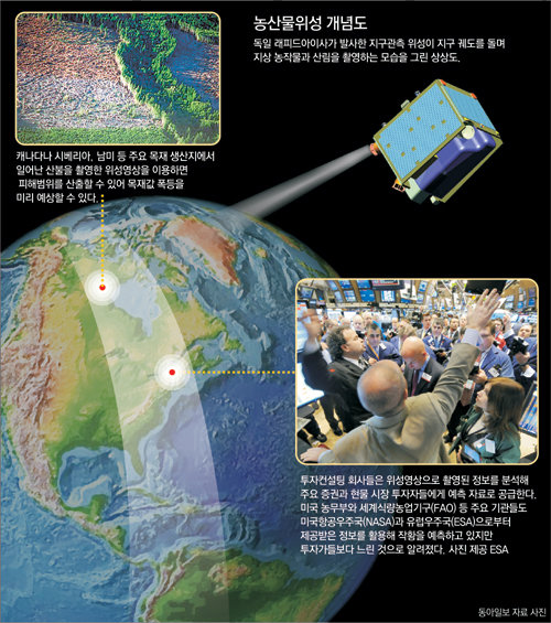
Major agricultural products such as corn and wheat are traded on the Chicago Mercantile Exchange. What choices should investors who buy wheat futures make if a drought hits major wheat producing areas such as the southern United States and Kazakhstan?
They have to keep wheat futures since they can sell them at higher prices next year, but must sell futures earlier than scheduled if the forecast is for an abundant crop next year. An accurate forecast of a good or bad harvest next year will result in much profit.
This is why investors have high interest in satellite images, which help investors estimate the output of agricultural products in each region. Investors using satellite images can collect data far faster than international organizations such as the Food and Agriculture Organization.
Satellite imaging technologies can also be used by forest investors, whose returns depend on the speed of tree growth. With demand for satellite images growing, certain companies have even specialized in crop yields in each region.
Germanys RapidEye launched five satellites in August last year to collect information on crop yields worldwide. The satellites photographed images of rapeseed details and distribution of wheat chlorophyll earlier this year.
RapidEye made crop reports based on the information collected by the satellites.
○ Korea ready for satellite images
Nobody in Korea uses satellite images to determine whether to invest in agricultural products. Nevertheless, the country has advanced satellite technologies adequate enough to photograph satellite images.
The amount of information satellite images provide depends on the performance of equipment. Satellites observe the earth with a variety of lights, including visible rays and infrared and ultraviolet light. Electro-optical cameras recognizing objects five meters wide and five meters long are enough to collect information on crop yield, tree distribution and damage from blight and harmful insects.
If black-and-white images are added to color information, tree species and agricultural product types can be recognized. If images are taken by synthetic aperture radar having eight gigahertz, the height and thickness of trees can also be calculated.
Korea is operating the multipurpose satellite Arirang 2, which can discern objects one meter wide and one meter long. If the Communication, Ocean and Meteorological Satellite is launched this year, Arirang 5 next year, and Arirang 3 in 2011, the country can collect all kinds of satellite images.
Yong Sang-sun, a manager at Korea Aerospace Research Institute, said, If data on optical and radar images collected by Arirang 3, Arirang 5 and the Communication, Ocean and Meteorological Satellite are combined, we can predict crop yield, how much fish can be caught off nearby coasts, and changes in forest distribution resulting from climate change.
kunta@donga.com