Tropical storm Hagibis set to become a strong typhoon
Tropical storm Hagibis set to become a strong typhoon
Posted October. 07, 2019 07:20,
Updated October. 07, 2019 07:20
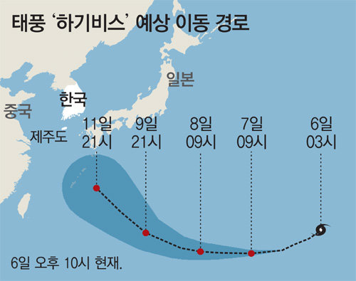
Tropical Storm Hagibis (a Filipino word meaning “swift”) broke in the east coast of Guam, the United States this morning. The Korea Meteorological Administration (KMA) forecasts that this will be the strongest storm experienced by the Western Pacific Ocean this year. It remains unclear whether the storm will pose a danger the Korean Peninsula.
According to the KMA on Sunday, Hagibis was 1,050 kilometers east of Guam at 3 p.m. on the day, moving west at 36 kilometers per hour. It is currently a mild, small storm with the strong wind radius of 200 kilometers and the center max wind speed of 24 meters per second but is forecast to intensify into “a very strong, medium typhoon.” The weather agency expects that the strong wind radius and the center max wind speed of Hagibis will increase to 450 kilometers and 53 meters per second, respectively, by Thursday afternoon. The central pressure is expected to fall to 920hPa.
Whether South Korea will be affected is still unknown. “There is a high possibility that Hagibis will head towards Kyushu, the north-eastern part of Japan, after hitting Okinawa later this week,” the KMA said. “It is still early to be rest assured as the storm’s track might change to surrounding atmospheric pressure.”
4g1@donga.com